

Collins Brook Headwaters
Scroll down for directions, trail information and property information.
Description
The Collins Brook Headwaters property is a 100-acre tract in the northwest corner of the Dinsmore Brook to Shattuck Pond land conservation area, a 2500-acre block of unfragmented land in Francestown, most of which is preserved conservation land. It shares borders with both the Dinsmore Brook Conservation Area which is owned by the Town and managed by the Francestown Conservation Commission and a large privately-owned conserved property.
Owned by the Brien Family as a tree farm since 1970’s, the family sold it to the Francestown Land Trust (FLT) in 2017. The purchase was made possible by a number of grants from the New Hampshire Land and Community Heritage Investment Program (LCHIP), NH State Conservation Committee (Moose Plate), Fields Pond Foundation, Quabbin-to-Cardigan Partnership, Davis Foundation, the Francestown Conservation Commission and an anonymous grant. There were also significant private contributions, and many hours of donated time and services that helped make this project happen.
Old stone walls in & along the property attest to the farming history in the nineteenth and probably the eighteenth century. There are no cellar holes on the property, but there is an old homestead site very near the northeast corner of the property. The land was most likely pasture for sheep and or cattle with little if any cultivated soils. The second growth forest has been selectively harvested periodically over the last 150 years, most recently in 2010.
Directions to the Trail Head
From the intersection of Routes 136 and 47 in the center of Francestown, follow Rte. 47N toward Bennington. After 3.4 miles, turn right onto School House Road. After 1.0 mile (4.4 miles total) turn right onto Wilson Hill Road. After .5 mile the parking area and trailhead kiosk (coming in 2026) is on your right. There is off-road parking suitable for 2-3 cars at the beginning of the access road before it is cabled off. .
Trails
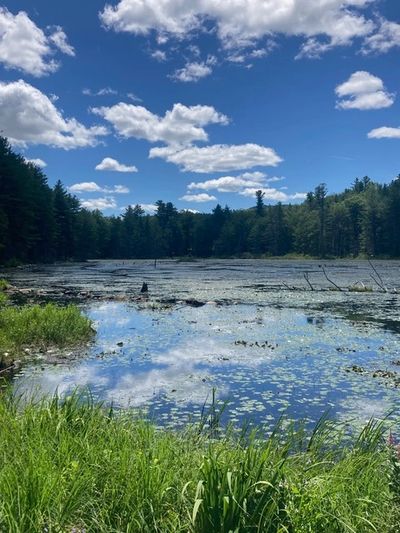
Starting at the kiosk for the Collins Brook Headwaters on Wilson Hill Road, a quarter mile long “logging truck road” heads into the center of the property. The road brings you to a clear overlook of a beaver pond. From here you can walk over a small inlet to the pond and continue up a short distance where the road ends in an open area. It makes for a nice, short woods walk, suitable for walkers of all levels, with a destination in mind, and a bench to sit on at the beaver pond.
Natural History
The property, accessed off Wilson Hill Rd., contains approximately 5600’ of headwater streams contributing to Collins Brook, frontage on two remote ponds, wet meadow/shrub wetlands, several vernal pools, and a swamp. With its diverse mix of upland Appalachian oak-pine and Hemlock-hardwood forest of beech, red maple, black and white birch; the 2015 NH Wildlife Action Plan Habitat Maps categorize 40% of the property as “Highest Ranked Habitat in NH”, 50% as Highest Ranked Wildlife Habitat in the Region and 10% as “Supporting Landscapes”.
This property has a most prolific wildlife habitat, supporting observed wildlife in the area or the adjacent Dinsmore Brook Conservation Area of black bear, river otter, coyote, bobcat, turkey vultures, turkey, broad-wing hawk, white tailed deer, moose, weasel, mink, spotted salamander and turtles.
Forest Management
The Francestown Land Trust adopted a Stewardship Plan in 2017 which provides guidance for protection and educational, scientific and recreational use. This reflects FLT’s commitment to preservation of high-quality habitat and protection of water quality while offering excellent outdoor recreation opportunities including but not limited to, walking, hiking, cross-country skiing, snowshoeing, hunting and fishing.